
The Global Positioning System is a space-based radio navigation and timing system that determines precise position by measuring signal travel time from multiple orbiting satellites to a receiver on Earth. Because each satellite transmits highly accurate time-stamped signals along with orbital data, a receiver calculates distance to each satellite and solves a geometric position in three dimensions. As a result, GPS provides continuous global positioning, velocity determination, and ultra-precise time synchronization for civilian, scientific, industrial, military, and amateur radio applications.
Introduction to GPS as a Global Measurement System
The Global Positioning System operates as one of the most complex and precise engineering systems ever deployed at planetary scale. It integrates orbital mechanics, atomic physics, radio frequency propagation, signal processing, and statistical estimation into a unified global infrastructure. Because satellites broadcast synchronized timing signals continuously, receivers anywhere on Earth with a clear view of the sky can compute their location without reliance on local infrastructure.
Although most people associate GPS with navigation, it functions primarily as a global time-distribution system that enables position through synchronized measurement. Telecommunications networks depend on GPS time to coordinate transmission windows. Financial markets require nanosecond-level timestamp synchronization. Electrical power grids maintain phase stability using GPS-based timing references. Aviation, maritime navigation, surveying, agriculture, emergency services, and scientific research rely on GPS positioning for safety and precision.
Additionally, GPS operates continuously across land, sea, and air. Receivers obtain measurements in deserts, mountains, dense urban environments, offshore platforms, aircraft, and remote expedition locations. Therefore, GPS serves as foundational infrastructure supporting modern civilization.
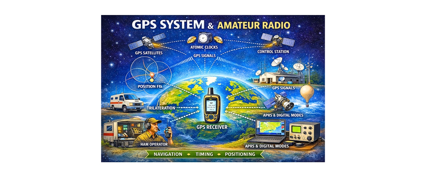
System Architecture: Space, Control, and User Segments
GPS operates through three coordinated segments.
The space segment consists of satellites orbiting Earth in medium Earth orbit at approximately 20,200 kilometers altitude. Each satellite carries multiple atomic clocks and continuously transmits timing and navigation data.
The control segment includes globally distributed monitoring stations that track satellite orbits, measure clock drift, calculate corrections, and upload updated navigation data. Because satellite clocks and orbits must remain extremely accurate, ground control continuously maintains synchronization and health.
The user segment consists of receivers that measure signal delay, compute pseudorange distances, correct internal clock bias, and solve for three-dimensional position and time.
These segments operate as an integrated measurement network delivering global coverage.
Constellation Geometry and Orbital Mechanics
GPS satellites orbit in six orbital planes inclined approximately 55 degrees relative to the equator. Each satellite completes an orbit roughly every 11 hours and 58 minutes. Because this orbital configuration distributes satellites evenly across Earth, at least four satellites remain visible from nearly any location.
Satellite geometry significantly influences solution accuracy. When satellites are widely separated across the sky, geometric dilution of precision values improve, resulting in stable positioning. Conversely, clustered satellites degrade solution stability.
Satellites transmit two key orbital data sets:
Ephemeris data, which provides precise short-term orbital parameters.
Almanac data, which provides coarse orbital predictions for the entire constellation.
Receivers use almanac data to locate satellites quickly and ephemeris data for accurate position calculation.
Trilateration, Pseudorange, and Mathematical Position Solution
GPS positioning uses trilateration. Each satellite transmits a precise timestamp. The receiver measures the time difference between transmission and reception to compute signal travel duration. Because radio waves travel at the speed of light, travel time converts directly to distance.
However, measured distance is called pseudorange because receiver clocks are not perfectly synchronized with satellite atomic clocks. Therefore, the receiver solves four simultaneous equations to determine latitude, longitude, altitude, and clock bias.
Mathematically, each satellite defines a sphere of possible locations. The intersection of multiple spheres determines the receiver’s position. Receivers use least-squares estimation to minimize measurement error and produce a stable solution.
Atomic Clocks and Relativity
GPS depends on nanosecond-level timing precision. Satellites carry atomic clocks based on stable atomic resonance frequencies. Because signals travel at approximately 300,000 kilometers per second, a one-microsecond timing error would create a 300-meter position error.
Relativistic physics affects satellite clocks. Satellites move rapidly and experience weaker gravity than Earth’s surface. Both velocity and gravitational potential alter time flow. Engineers apply relativistic corrections so satellite clocks remain synchronized with ground time.
Without these corrections, errors would accumulate rapidly and render positioning unusable.
GPS Signal Structure and Frequency Bands
GPS satellites transmit on multiple L-band frequencies:
L1 at 1575.42 MHz
L2 at 1227.60 MHz
L5 at 1176.45 MHz
Signals contain:
Precise ranging codes
Navigation data
Satellite health information
Receivers correlate known pseudorandom codes with received signals to measure timing offset. Multi-frequency receivers compare signal delays to correct ionospheric distortion because ionospheric delay varies by frequency.
Modern signal structures include improved modulation schemes that increase robustness and accuracy.
Atmospheric Effects and Error Modeling
Signals pass through the ionosphere and troposphere before reaching receivers. The ionosphere causes dispersive delay due to charged particle density. Dual-frequency receivers correct this delay by comparing propagation differences between frequencies.
The troposphere causes non-dispersive delay influenced by pressure, humidity, and temperature. Receivers apply atmospheric models to estimate these delays.
Although atmospheric effects introduce error, modern correction techniques significantly reduce impact.
Dilution of Precision and Satellite Distribution
Dilution of precision quantifies how satellite geometry influences measurement uncertainty.
Geometric dilution reflects total positional uncertainty.
Horizontal dilution affects latitude and longitude precision.
Vertical dilution affects altitude accuracy.
Lower dilution values correspond to stronger geometry and improved precision.
Receiver Operation and Signal Processing
GPS receivers detect extremely weak satellite signals. First, the receiver scans known code sequences to acquire satellites. Once acquired, it tracks signal phase and timing continuously.
Receivers compute pseudorange, apply atmospheric corrections, compensate for clock bias, and solve position using iterative estimation. Advanced receivers apply filtering techniques such as Kalman filtering to reduce noise and improve stability.
Carrier phase tracking allows measurement of fractional wavelength differences, enabling centimeter-level positioning when integer ambiguity is resolved.
High-Precision Positioning: RTK and Differential GPS
Differential positioning uses reference stations at known locations to calculate measurement error and broadcast corrections.
Real-Time Kinematic positioning uses carrier phase measurements and ambiguity resolution to achieve centimeter-level accuracy. Precise Point Positioning applies global correction models for high accuracy without local base stations.
These techniques support surveying, construction, scientific monitoring, and precision agriculture.
Initialization States
Cold start occurs when the receiver lacks satellite data. Warm start uses stored almanac information. Hot start uses recent satellite tracking data for rapid acquisition.
Initialization affects time-to-first-fix performance.
GPS as Global Time Infrastructure
Beyond navigation, GPS distributes precise time worldwide. Cellular networks synchronize base stations. Financial markets timestamp trades. Power grids coordinate transmission phase alignment.
Therefore, GPS functions as a global time reference supporting critical infrastructure.
Security, Interference, and Resilience
GPS signals are weak at Earth’s surface and vulnerable to interference. Jamming overwhelms signals. Spoofing transmits false signals to mislead receivers.
Modern systems monitor interference and incorporate detection mechanisms. Multi-constellation receivers improve resilience by tracking multiple satellite systems simultaneously.
GPS Modernization and Satellite Generations
Satellite generations have evolved through multiple blocks, each introducing improved signal capability, clock performance, and power output. Newer satellites transmit additional frequencies and enhanced coding structures that improve accuracy and robustness.
Ongoing modernization increases resistance to interference and supports future integration with additional navigation systems.
Environmental and Operational Limitations
GPS requires line of sight to satellites. Buildings, dense foliage, underground environments, and heavy obstruction reduce signal strength. Urban reflections create multipath distortion.
Although modern receivers mitigate many effects, clear sky visibility remains essential for optimal performance.
GPS Functions and Amateur Radio Applications
| GPS System Function | What It Does Technically | Why It Matters | Amateur Radio Use | Real-World Example |
|---|---|---|---|---|
| Satellite Positioning | Measures distance from multiple satellites using signal timing | Determines exact geographic location | Mobile station tracking | APRS beacon showing vehicle position |
| Precision Time Synchronization | Provides atomic-clock based universal time reference | Keeps systems synchronized to microseconds | Digital mode timing alignment | FT8 transmissions starting exactly on time slots |
| Velocity and Motion Tracking | Calculates speed and movement direction from position changes | Enables real-time tracking and navigation | Mobile tracking and event coordination | Tracking marathon support communications |
| Trilateration Geometry | Solves 3D position from multiple satellite ranges | Enables accurate global navigation | Automatic location reporting | Portable operator transmitting grid square |
| Multi-Frequency Signal Reception | Uses multiple bands to correct atmospheric delay | Improves positioning accuracy | High precision field operations | Accurate location reporting for emergency response |
| GPS-Disciplined Oscillator Reference | Uses GPS time to stabilize frequency standards | Maintains extremely stable RF frequency | Precision frequency control | Microwave weak-signal experimentation |
| APRS Data Integration | Combines GPS location with packet radio transmission | Enables real-time network mapping | Automatic Packet Reporting System | Tracking weather stations or mobile rigs |
| Satellite Tracking Support | Provides exact observer location for orbit prediction | Enables accurate antenna pointing | Amateur satellite communication | Calculating Doppler shift for satellite passes |
| Propagation Experiment Timing | Synchronizes transmissions across locations | Enables scientific measurement of signal travel | Coordinated propagation testing | Measuring VHF signal delay over distance |
| Emergency Location Reporting | Provides accurate coordinates during incidents | Improves response coordination | ARES / RACES deployment | Reporting disaster assessment locations |
| High-Altitude Telemetry | Transmits real-time position from airborne platforms | Enables recovery tracking | Balloon and experimental launches | Tracking payload landing zone |
| Network Synchronization | Provides consistent time reference across systems | Enables coordinated communication networks | Digital repeater linking | Time-aligned digital voice networks |
GPS in Amateur Radio Operations
Critical role in modern amateur radio activity.
APRS Position Reporting
Automatic Packet Reporting System relies on GPS receivers to provide real-time latitude and longitude data. Because mobile stations transmit position packets automatically, operators track station movement accurately during events, emergency response, and public service operations.
Time Synchronization for Digital Modes
Digital weak-signal modes such as FT8, FT4, and other time-synchronized protocols require accurate clock alignment. GPS-disciplined oscillators provide highly stable timing references, ensuring transmission windows align precisely.
Microwave and VHF/UHF Propagation Research
Amateur radio operators use GPS time synchronization to conduct propagation experiments, measure signal delay, and coordinate simultaneous transmission testing across wide geographic areas.
Satellite and High-Altitude Balloon Tracking
Amateur satellite operators rely on GPS position data to calculate Doppler shift and predict satellite passes. High-altitude balloon projects transmit GPS telemetry for recovery tracking.
Precision Frequency Control
GPS-disciplined oscillators stabilize frequency references in advanced amateur radio stations. Because GPS provides long-term timing stability, frequency drift decreases significantly.
Emergency Communication
In emergency scenarios, GPS provides accurate incident location data, improving coordination between amateur radio volunteers and response agencies.
Consequently, GPS has become an essential component of modern amateur radio infrastructure.
Practical Accuracy Expectations
Standard civilian GPS achieves meter-level accuracy under normal conditions. Augmented systems provide sub-meter precision. Carrier phase techniques deliver centimeter-level accuracy.
Actual performance depends on satellite geometry, atmospheric conditions, receiver quality, and environmental obstructions.
Improving GPS Performance in Practice
Maintain unobstructed sky view.
Use multi-frequency receivers when possible.
Allow receiver warm-up for stable clock bias correction.
Minimize reflective surfaces near antenna.
Use augmentation systems where available.
Ethical and Regulatory Considerations
Radio spectrum regulation protects GPS frequencies from interference. Because GPS supports critical infrastructure, protecting signal integrity remains essential.
Privacy concerns arise when tracking personal location data. Responsible use requires balancing technological capability with ethical considerations.
Frequently Asked Technical Questions
Why are four satellites required?
Three determine spatial position while the fourth corrects clock bias.
Why does satellite geometry affect accuracy?
Because spatial distribution influences measurement uncertainty.
How does ionospheric delay correction work?
By comparing propagation delay across multiple frequencies.
Why is GPS important in amateur radio?
Because it provides position reporting, digital mode timing, and frequency stabilization.
Professional Technical Perspective
GPS integrates orbital dynamics, relativistic physics, radio engineering, atmospheric science, and statistical estimation into a continuously operating global measurement system. Its architecture demonstrates coordinated engineering across space and ground systems at planetary scale.
GPS and Ham Radio
GPS provides continuous, global, high-precision positioning and timing through synchronized satellite transmission and geometric computation. Because modern infrastructure, scientific research, communications networks, financial systems, and amateur radio operations depend on synchronized time and accurate location, GPS functions as a foundational technological utility. Ongoing modernization, multi-constellation integration, and high-precision techniques ensure that GPS will remain central to global technological systems for decades to come.
Please consider Donating to help support this channel