Tropospheric ducting is a fascinating phenomenon that allows radio signals, especially in the VHF and UHF bands, to travel far beyond their normal line-of-sight range. How to predict tropospheric ducting requires understanding several factors, including atmospheric conditions, weather reports, and propagation readings.
Tropospheric ducting occurs when temperature inversions trap radio signals between layers of the atmosphere, creating a duct that guides them across hundreds or even thousands of miles. Because this effect can greatly enhance communication distance, ham radio operators, marine radio users, and even broadcast engineers closely monitor the conditions that lead to ducting.
Understanding the Basics of Tropospheric Ducting
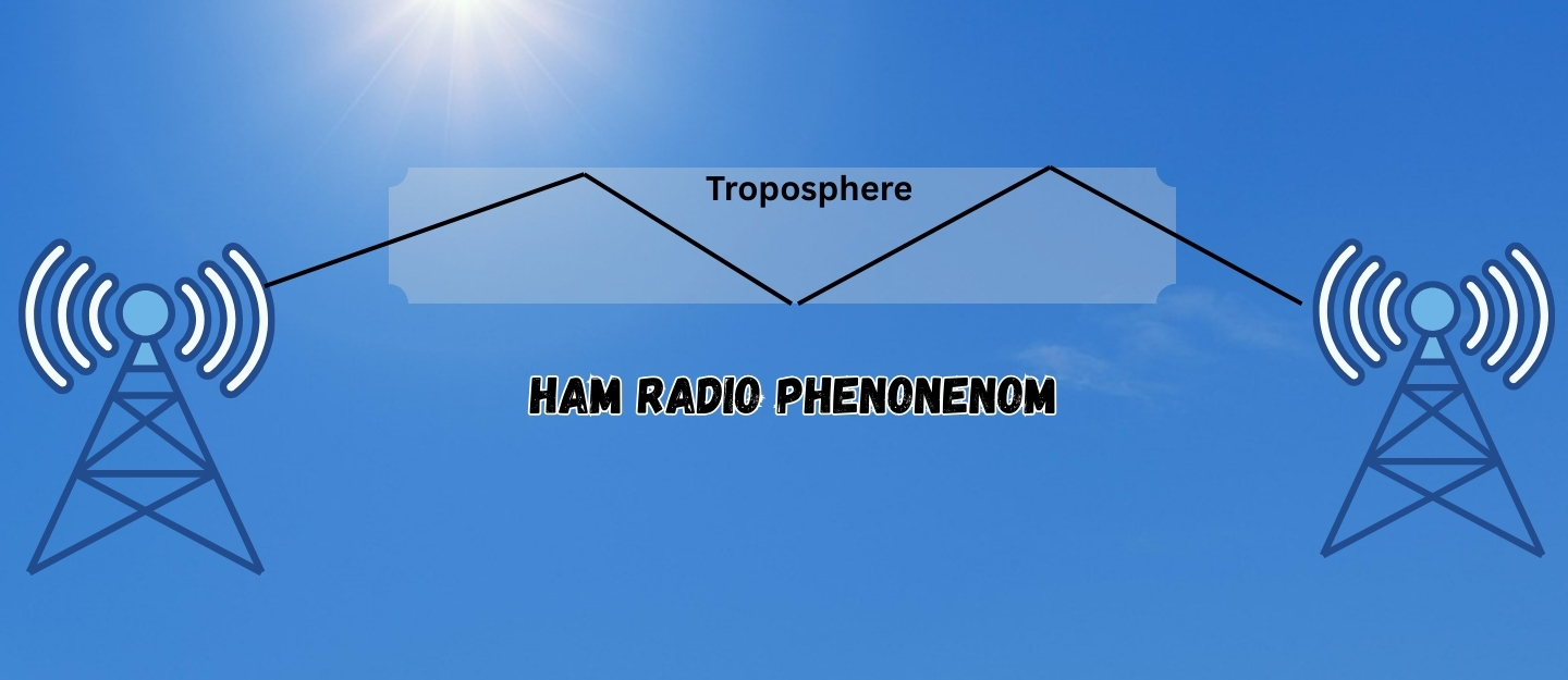
The troposphere is the lowest layer of the Earth’s atmosphere, where weather activity occurs and where most radio communication takes place. Normally, radio signals at VHF and UHF frequencies travel in a straight line and eventually weaken as they move beyond the horizon. However, when a temperature inversion forms, warm air sits above cooler air near the surface, creating a refractive layer.
This refractive layer bends the radio waves back toward the Earth, allowing them to follow the curvature of the planet. When multiple layers of inversion stack together, they form a duct that traps and channels the signal for very long distances. Understanding this process is crucial for predicting when ducting will occur.
Key Weather Conditions to Watch For
To predict tropospheric ducting, you must monitor specific weather patterns. High-pressure systems are the most common source of ducting conditions. Under high pressure, the air sinks and warms, creating stable weather with calm winds and clear skies. These conditions often lead to temperature inversions near the surface.
Additionally, nighttime cooling after a hot day frequently produces surface-based inversions, especially over water. Because bodies of water cool and heat at different rates compared to land, coastal areas are prime locations for ducting events. Mariners often experience extended VHF marine radio range during these conditions.
Furthermore, fog, haze, and calm weather can indicate the presence of an inversion layer. When these visual signs appear, there is a strong possibility of enhanced propagation. However, ducting is less likely during periods of low pressure, strong winds, or turbulent weather because these conditions mix the air and disrupt the inversion layer. Therefore, paying attention to local forecasts and observing the environment plays a vital role in predicting ducting opportunities.
Using Propagation Readings
Propagation reading tools can help you confirm potential ducting conditions before they fully develop. Online propagation maps and graphs track tropospheric enhancement levels in real time. These tools use weather data, temperature profiles, and atmospheric models to estimate where ducts are forming.
The readings usually display color-coded maps showing areas of weak, moderate, or strong enhancement. By checking these maps, you can determine whether to expect extended range in your area.
Temperature and humidity data are also valuable for prediction. A rapid change in temperature over a short vertical distance, known as a temperature lapse rate, indicates a strong inversion. Radiosondes and weather balloons provide this data, but many online weather services also display simplified charts showing inversion layers.
When you notice a sharp inversion, it is an excellent sign that ducting may soon occur. Always compare these readings with current and forecasted conditions to anticipate when the duct will strengthen or weaken.
Interpreting Weather Reports for Ducting
Weather reports and forecasts provide vital clues for predicting ducting. Look for reports that mention high-pressure ridges, stable atmospheric conditions, and clear skies. Marine forecasts often specifically reference temperature inversions and describe their impact on visibility and weather stability. If a forecast predicts several consecutive days of calm, clear weather, the chances of ducting increase dramatically.
Nighttime and early morning hours are especially important. After sunset, the ground cools faster than the air above it, creating a surface-based inversion. These inversions can form strong ducts, especially near large bodies of water.
As the sun rises and heats the surface, the inversion breaks down, reducing the ducting effect. Therefore, the best time to listen or transmit for long-distance communication is often late at night through early morning.
Tools and Resources for Predicting Ducting
Modern technology makes it easier than ever to predict tropospheric ducting. Several websites and mobile apps specialize in providing propagation forecasts. These tools combine weather models with radio propagation algorithms to generate accurate predictions.
Additionally, ham radio communities often maintain online forums and real-time reporting networks where operators share their observations. By comparing your local conditions with reports from nearby areas, you can refine your understanding and improve your prediction skills.
Wean radar can also provide indirect clues, when radar images show unusual patterns or extended range, it can indicate atmospheric conditions that support ducting. Some weather radars detect signals bouncing within ducts, which appear as false echoes or extended coverage areas. Monitoring these anomalies can give you an early warning of a developing duct.
Practical Steps to Prepare for Ducting
Once you identify favorable conditions, take steps to maximize your communication success. First, ensure your radio equipment is ready. Check your antennas, coaxial cables, and power supplies to prevent equipment failures during peak conditions. Next, program the frequencies you intend to monitor, such as repeaters, simplex channels, and marine bands. Because ducting events can develop quickly, having everything prepared allows you to take advantage of the opportunity immediately.
Additionally, keep detailed logs of your observations. Record the date, time, weather conditions, and signal reports for each ducting event you experience. Over time, these logs will reveal patterns specific to your location, improving your ability to predict future events. Comparing your logs with online reports also helps confirm your findings and build a more accurate understanding of local propagation behavior.
Combining Knowledge and Observation
How to predict tropospheric ducting is part science and part experience. While weather data and propagation maps provide valuable information, your personal observations are equally important. By combining knowledge of atmospheric conditions with direct monitoring of radio signals, you can develop a reliable prediction method. Over time, you will learn to recognize subtle signs, such as a slight increase in signal strength or unusual noise patterns, that indicate a developing duct.
Because tropospheric ducting depends on many variables, it is never completely predictable. However, with careful study and regular practice, you can significantly improve your success rate. The reward is the thrill of making long-distance contacts far beyond normal range, a highlight for any radio operator.
Final Thoughts
Tropospheric ducting offers exciting opportunities for VHF and UHF communication enthusiasts. By understanding the role of temperature inversions, monitoring weather reports, interpreting propagation readings, and staying prepared, you can predict and take advantage of these rare events.
Consistent observation and practice will sharpen your skills, allowing you to recognize patterns and maximize the benefits of this fascinating atmospheric phenomenon. Through a combination of science and hands-on experience, you can master the art of predicting tropospheric ducting and enjoy the challenge of extended-range communication.
Please consider Donating to help support this channel